Day 3358 (Tuesday) 18th August 2026
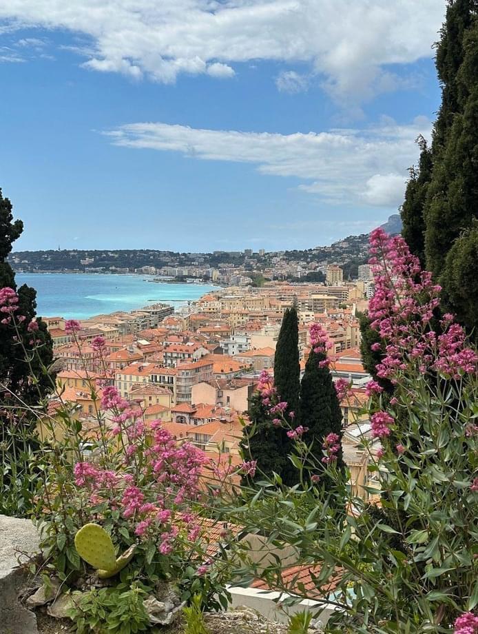
This is Menton

and this is La Roya, North of Nice.

It was very hot and humid again today and we decided to go and see the crypt in Nice thinking it would be cool in there, but first we had our weekly kebab in the park. There were some fully grown young men playing on the seesaw, it was very entertaining.

This is the entrance to the crypt.

Digs of the Metropolis’ tram line shone exceptional light on to Nice’s history, the Duchy of Savoy’s fortified stronghold for close to five centuries. The excavation of the Porte Pairolière entrance to the city along the river Paillon is particularly large-scale as it covers
approximately 2,000 m2. It was located at a critical point for the tram, close to the Place Garibaldi square. This dig had to adapt to the constraints of civil engineering.

THE FORTIFICATION OF THE PORTE PAIROLIERE
The Porte Pairolière was first mentioned in 1323 as the ‘Porte des Augustins’. It was the city’s main gateway to the North and Italy. The uncovered walls bear witness to spectacular construction that may date back to the early 16th century. Texts tell of a 15th century moat and drawbridge system, of which masonry remains have been found. Illustrations of this gateway are fairly scarce, yet one detail from an altarpiece by Louis Bréa dates back to 1513 and depicts what might have been the Pairolière gateway and tower prior to development works on the Saint-Sébastien bastion.

On the Paillon side, the gateway is annexed to a very wide tower with a diameter of over 8 metres in the upper section) that flares out to the ground. This tower remained a feature on the landscape until the fortification was demolished in the early 18th century, yet it was stripped of its military purpose in the early 16th century, when the Pairolière bastion was built to reinforce the gateway’s defences. The hollow tower surrounded older ruins, probably linked to earlier stages in the fortifications.

The gateway was reinforced in the 15th century with the building of a ravelin, an advanced type of fortification located beyond the moat and designed to protect its bridge. It included many arrowslits , which are mentioned in texts dating back to 1490-1510.
The ravelin was built on the ancient road by destroying the walls that bordered it, vestiges of suburban properties.
The fortification exit was built in the form of a new gateway protected by an extension of the western orillon. This opening is situated close to the old ravelin doorway. It is of particular importance because it survived in the extension of the bastion, as we will see further on. Ultimately, this type of bastion takes the shape of later bastions.
However, the dense thickness of the outer stonemasonry (over 4.30m) combined with the internal hollow space, are archaic signs that point to a simple yet improved ravelin. The period in which the bastion was probably built is of particular interest. It was a continuation of the rebuilding of the northern face of the castle’s fortifications (from 1516) and of the section of the rampart close to the bridge’s gateway (as indicated by the inscription found during the dig). It was therefore a total rehabilitation of the city and not just the upper section of the city as had previously been believed. The siege of 1543 left a few marks on the site. The most definite among them are cannonball impacts on the outer facing of the Pairolière bastion.
THE FIRST PAIROLIERE BASTION

The 16th century marked a turning point in the history of Nice’s defence system. All of the fortifications were rebuilt to adapt the site to new war techniques. This reconstruction was made obligatory by the Franco-Ottoman siege in 1543, which resulted in a section of the medieval defences that were largely disused being destroyed, although some alterations had already been made, such as the building of the first Pairolière bastion. Three elements of the first Saint-Sébastien bastion are known to us as certain: the north-eastern wall, the western cavalier tower and the steps of the tower. Once rebuilt, the rectangular building of the first Porte Pairolière served as an access passageway to the bastion. A chapel dedicated to Saint Sebastian is accounted for in the late 15th century outside the Porte Pairolière. After a hiatus in documentation (most certainly destroyed in 1543), it is mentioned again in 1581.
The revival of worship of Saint Sebastian is confirmed in the rebuilding of the chapel annexed to the tower.
THE REBUILDING OF THE PAIROLIERE BASTION
As with older stages, no archive documents recorded the building of this bastion. However, one written document dating back to 1570 ordering work to be carried out on the bastions may well serve as a starting point for this. Dating it to the ensuing decade is at any rate coherent with archaeological and iconographical data. Extension work carried out on the bastion seems to have exclusively taken place on its north-eastern face. The second bastion matches our ‘traditional’ knowledge of this type of work: the wall is thinner (approx. 3 metres) and is reinforced by load-bearing walls laid out along its inner side, with the entire structure backfilled to create an overarching platform. The Balduino viewing point, in 1610, is the perfect illustration of this new construction that barely dates back a generation.
The construction of a new bastion led to the disappearance of the northern part of the building’s gateway (meaning that only one section of the wall with the passageway was visible next to the tower from the Balduino viewing point). A terrace wall was built to hold down the platform ground, thus allowing for an enclosed passageway linking up to the old outer gateway of the first bastion. The old orillon was probably maintained, enclosed by the second bastion’s overlapping orillon designed to reinforce the framework.
The first 17th century developments in terms of fortifications correspond to the digging of a moat alongside the new Pairolière bastion between 1611 and 1616This project dates back to the late 16th century and features on drawings of Nice’s fortifications by Ercole Negro.
The bridge leading out from the bastion is a fairly typical construction, featuring the use of brick that was so frequent in Nice during this period
THE DIG
Archaeological operations on the tram line were carried out in accordance with preventative archaeology legislation. After archaeological diagnosis revealed the presence of the Pairolière tower (under the Boulevard Jean-Jaurès) and the bridge that once forded the moat (under the Place Garibaldi), the DRAC (Ministry of Culture and Communication) defined the scope of work (2,000 m2) and the depth of the dig (6 m) to be carried out. The latter was carried out by the Inrap, with scientific management provided by Marc Bouiron (City of Nice). The excavation was carried out in two stages, first in the open air and then following the setting up of posts2 designed to support the tram line, under a closed slab. After total excavation work of 8 months, all of the ruins were fully uncovered. The construction of a concrete wall around the site prior to the excavation allowed this exceptional site and archaeological crypt to be preserved.
We only had to pay 5€ entrance fee and we got a handset each and it was lovely to hear a nice English accent and not an American. As I said earlier we thought that it would be nice and cool in there because it’s underground but we were both sweating a lot and it was good to get out but we had a lovely afternoon.




Comments
Post a Comment